Conservation from Data
A data point does not make a trend. Illustrative proof.

The Role of Data in Conservation
Climate change has a tendency of turning “normal” into a moving target.
That is why conservation increasingly relies on quantitative surveys rather than intuition. At Löwen River Rewilding, data serves four main purposes:
Recording a baseline (or admitting we guessed wrong and adjusting it)
Calibrating restoration efforts
Benchmarking against control areas
Evaluating long-term impact
Whether through gabions, half-moons, regreening, fence removal, or eventually reintroducing game (let’s start with springbok before we copy the neighbours with black rhinos!), the goal remains the same: measure what works, and learn from what does not.
As explored in Conservation from the Mind, we want conservation to become more than a philosophy or a desk-research project. Our ambition: active restoration aimed at (re)building self-sustaining biodiversity.
The challenge, of course, is that ecosystems refuse to operate in Excel tables. Weather influences vegetation. Vegetation shapes insect life. Insects affect birds. Birds influence fauna. And all shifts across time, rainfall, temperature and terrain.
No wonder building a digital twin of nature can feel daunting. Somewhere between 🎮 SimCity: Desert Edition and Minecraft.
From Space: Satellites
Let’s start from the macro and work our way down.
Satellite imagery has become so common through Google Maps and Earth that we forget its origins were less innocent: military surveillance and damage assessment. The first images from space were captured in 1946 by the United States.
Today, satellite resolution ranges from 30 meters with NASA’s Landsat program — the world’s longest continuous Earth-observation mission — down to roughly 41 centimeters with GeoEye-1.
Applications now extend far beyond mapping and weather forecasting:
agriculture
environmental and wildlife monitoring
urban planning
and, tax collection
(If you forgot to declare your swimming pool, French and Italian authorities have become experts at identifying your oversized garden bathtub from orbit)
Modern sensors no longer stop at visible light. We moved from RGB imagery to infrared and thermal bands capable of detecting vegetation health, moisture and surface temperatures.
Which means Löwen River, before the rains, occasionally resembles a giant red curry.

Courtesy of EOS Data Analytics, the comparison above uses Sentinel-2 imagery from February 6 and May 2, 2026.
The NDVI — Normalized Difference Vegetation Index — measures the contrast between near-infrared light reflected by healthy vegetation and red light absorbed during photosynthesis.
Before the last 20mm of rain on May 1st, the overall NDVI index had already tripled. Roughly 4,500 hectares (11,000 acres) shifted from bare soil to fresh vegetation cover — mostly pioneer plants and annual flowers. Values range from -1 to 1. In simpler terms: Green is thriving, and red means nature is preparing a comeback.

MSAVI (Modified Soil Adjusted Vegetation Index) pushes the analysis further by detecting very early growth stages in sparse environments.
Computers then transform those colourful abstractions into measurable surface areas, vegetation density maps, and trend analysis over time.
Closer to Earth: Drones
If satellites give the bird’s eye view, drones provide front-row seats.
Our friends at Kuzikus (Barend and Fritz Jr.) began collaborating in 2021 with the Swiss non-profit Drones for Earth.
The organisation combines expertise from partners including EPFL, PIX4D, and senseFly/EagleNXT to produce ultra-high-resolution 3D mapping.
Over several days, fixed-wing drones fly automated paths across reserves the size of Kuzikus and Löwen River, generating around 36,000 images. After processing and AI treatment, the resulting maps achieve resolutions of roughly 4 cm.
At that level, wildlife monitoring changes completely. Tracks become visible. Animal counts become more accurate. Habitat use becomes measurable rather than anecdotal.
The same technology is also helping scientists monitor Alpine glaciers with unprecedented precision — building long-term datasets to better understand climate change.
So yes, conservation increasingly feels less like Minecraft and more like The Legend of Zelda (watch out for the movie release in 2027). If the stars align, Löwen River’s first Drones for Earth mission should happen around then.
Back on the Ground
Not all conservation technology flies.
Camera traps and fixed-point photography remain some of the most valuable tools available — combining patience, consistency, and stealth in ways humans rarely manage.
BBJ on 6 May BBJ x2 at the ground dam
(can you spot the differences over 10 days?)
They help us (refresher: Bits and atoms):
✅ Count and identify animals
✅ Track migration and movement patterns
✅ Compare seasonal behaviour
✅ Build collaborative datasets with researchers and conservation partners
And occasionally capture moments that make us question who is truly observing whom.
The Rise of Sensors
Once visual identification reaches its limits, sensors take over. Which brings us back to springbok.
As much as we would love future reintroduced springbok to stay within our boundaries, they may decide the neighbours look interesting too. In a remake of “the grass is always greener on the other side”.
Tracking technologies now offer a range of possibilities depending on budget, coverage, and real-time requirements.
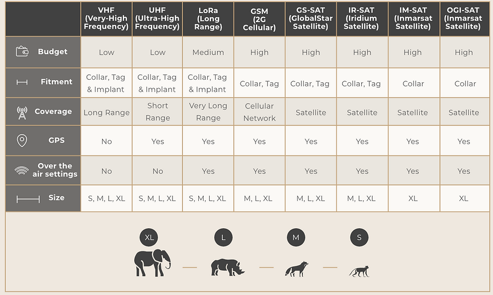
One area we are exploring is LoRaWAN, with guidance from experts including Smart Parks and Africa Wildlife Tracking.
Originally designed for the Internet of Things (IoT), LoRaWAN enables low-power devices to communicate across distances of 10–12 km while operating on batteries that can last several years.
In practice, this means a single network can support:
➡️ wildlife tracking
➡️ geofencing
➡️ rainfall monitoring
➡️ soil humidity sensors
➡️ borehole water levels
➡️ weather stations
➡️ asset tracking
In conservation terms: fewer unnecessary vehicle trips, lower fuel costs, faster reaction times, and more continuous monitoring.
Less guessing. More understanding.
Porcupines x2 Aardwolf BBJ at the farmhouse African Wild Cat Genet African Wild Cat (ground dam)
Heart. Mind. Data.
As Gift and Bernardo can testify in their research papers (in one of our next blogs), Conservation is becoming increasingly scientific, measurable, and data-driven — while remaining deeply human.
At Löwen River Rewilding, the ambition is to combine all three dimensions:
Heart — people and connection
Mind — philosophy and long-term thinking
Data — evidence, measurement, and adaptation
Because in the end, conservation is about understanding nature better.
“Fall in love with the problem; not the solution.” — Uri Levine


Comments